We did call them and announced our position, our intended course and asked for direction. They responded: "maintain course and speed; we have you on radar; we will notify you if you became an issue." Become an issue? How will we be notified?
It all ended up OK as the aircraft carrier was headed up the James River to Newport News--the opposite direction. Whew!!!!
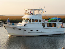
We cruised to Deltaville, VA, but ended up passing it because the weather was good, the seas were gentle and we only had a slight breeze from the north and a gentle falling tide. We went on to Reedville, VA. (Still on the western shore of the lower Chesapeake Bay.) We were going to anchor in Cockrell Creek, Great Wicomico River; but, Norm discovered a severe oil leak in the windless (anchoring mechanism) rendering it unusable. So, we took a slip in the Fairport Marina.
They have a pretty good restaurant and bar that specializes in soft shelled crabs and oysters. Need I say more.....?
We awoke this morning (Saturday) to head for Solomon's, Maryland. We checked the weather radar before we shoved off, as we usually do, and discovered another wave of storms approaching from the west. While they were not directly headed for us in Reedville, they were tracking directly toward a line from the Potomac River through Baltimore--our planned path today. Some of these storms were predicted to produce winds in excess of 50 mph. Our better senses said to stay. As it turned out, we saw severe storms pass over that area with upwards of 45 mph winds. We met others that pulled in here today to get out of the lightning and blinding rain. Our decision was the right one, even though it delays our homecoming.
So what are we trying to avoid? This, on the left! (Sometimes double clicking on the pic will expand the photo.)  When we say we look at weather radar, we look on web sites with our computer that give us real time pictures of current conditions. We also have other
  sources that give us text forecasts. Here is a pic on the right of the computer screen showing today's storms as of a few minutes ago. You can see that the storm cells have moved off the coast. The arrows indicate where the cell will be in an hour. The longer ones are moving faster than the shorter ones. They also show and tell us in what direction they are moving. Cool huh?
 When we say we look at weather radar, we look on web sites with our computer that give us real time pictures of current conditions. We also have other
  sources that give us text forecasts. Here is a pic on the right of the computer screen showing today's storms as of a few minutes ago. You can see that the storm cells have moved off the coast. The arrows indicate where the cell will be in an hour. The longer ones are moving faster than the shorter ones. They also show and tell us in what direction they are moving. Cool huh?
Unfortunately, tomorrow is not looking much better. Not storms, but strong blustery winds from the north and a strong falling tide (a new moon). When able, we'll depart for Solomons, MD and have Washburn's Boat Yard take a look at the windless; and then, we'll proceed north to Wilmington, DE, our home port. Wish us luck--we have to catch a plane for Milwaukee out of Philadelphia next Saturday!